
Formulating a hypothesis involves using all of the evidence to create a story that holds up, a bit like crime scene reconstruction. This, by combining geological, ecological (flora and fauna), and archaeological clues and dating them using proven dating methods, the history of the earliest inhabitants of the Eastern Townships region can be reconstituted. However, to put this history into context, one must examine signs from a North American perspective. This is how it was deduced that the earliest inhabitants travelled via Beringia during the retreat of the glaciers about 15 000 years ago. Descendants of these nomadic hunters, called Clovis, invented fluted points. Their descendants travelled across the continent to the Atlantic Ocean. About 13 000 years ago, a few hunters left New England to follow the caribou as far as the Eastern Townships. Over the course of the next two millennia, the glacier continued to retreat, and the landscape changed. New points of access to the area opened up. Hunters from another culture arrived from the west.
Clip produced by the Sherbrooke Museum of Nature and Science
Date: September 2018
Length: 8:02
An animated character, Éric Graillon, presents a hypothesis on the arrival of the first humans in the Eastern Townships based on geological, ecological (flora and fauna), and archaeological evidence dated using proven dating methods. However, to put this history into context, one must examine signs from a North American perspective.
The title: Hypothesis on Settlement, is displayed in a yellow rectangle in the middle of the screen. Behind it is a shaded illustration of a mountain.
[ Animated character ] Hypothesis on Settlement
On-screen: view of planet Earth from space. A close-up view of North America can be seen over the planet. The image of the continent fades, and square- and pointed-shaped artifacts appear. The photo fades and another appears with three experts in the process of analyzing a core soil sample on a flat surface on which there is a long tube. The photo fades and an image appears of artifacts numbered from 1 to 13 with an etching of a beaver.
[ A.C. ] To formulate a hypothesis on the settlement of the Eastern Townships, one must analyze evidence on a North American scale. All of the following must be taken into consideration: The shape of the artifacts found, the materials from which they were made, the soil, the pollen taken from sedimentary cores, the biofacts; and the maximum amount of information must by drawn from dating methods.
On-screen: geographical map of North America with the continent covered in ice, with the text “Laurentide Ice Sheet.” Glaciers can be seen in the background.
[ A.C. ] The first humans arrived on the North Amercian continent when the glaciers that had covered it for nearly 70 000 years began to retreat. Cartography and the dating of glacial deposits have made it possible to reconstitute the retreat of the glacier. The dating of artifacts found in the Bluefish Caves in the Yukon indicate human presence a bit over 20 000 years BP.
On-screen: scrolling geographical maps of the Northern region of the planet, between Siberia and Alaska: 20 000 years ago, when the water between the two regions was frozen; 15 000 years ago, when the water was partly frozen; and a current map, with the water fully thawed.
[ A.C. ] It's important to understand that the total amount of water on the planet was the same as today. Because an enormous amount of water was imprisoned in glaciers, there was less water in the oceans. Sea level was therefore much lower. This sea level revealed a passage between Siberia and Alaska, called Beringia.
On-screen: a video of a frozen lake.
[ A.C. ] The first big game hunters arrived via that passage. The ancestors of Indigenous peoples are therefore Asian. They are believed to have walked across the glacier and the coast. Artifacts and biofacts that are 20 000 years old have been discovered in Beringia, and others dating back 15 000 years have been found along the coast.
On-screen: a geographical map showing the distribution of the Clovis population in North America 13 000 years ago.
[ A.C. ] Starting 13 500 years ago, their descendants dispersed into North America. They are known as Clovis, from the name of the town where the first point was discovered.
On-screen: a photograph of three fluted points. On-screen: a geographical map of the St. Lawrence River region showing the movements of the Clovis from the Great Lakes to east of the St. Lawrence River.
[ A.C. ] The Palaeoindians of the time made tools and points with fluted parts to create a better grip or hold. 13 000 years ago, some Clovis descendants were around the Great Lakes and advancing east, south of the St. Lawrence River.
On-screen: image of various artifacts of different shapes (fluted arrowheads, more or less round, and of varying sizes).
[ A.C. ] The hypothesis of human migration is primarily based on typology, i.e. the dating method that classifies artifacts according to their similarity. It is assumed that the people who made fluted points were all part of the same tradition.
On-screen: a clip of a cross-section of soil with artifacts at different depths. Artifacts found at greater depths are identified as “more ancient” and artifacts at the surface as “more recent.”
[ A.C. ] Stratigraphy, i.e. the dating method based on the depth at which artifacts are buried, confirms that the first humans followed the ice margin. This technique also makes it possible to determine the order of arrivals.
On-screen: an interactive geographical map showing the evolution of the glacier melt, with the city of Sherbrooke and Champlain Sea indicated: 13 000 years ago, 12 900 years ago, 12 000 years ago, and 11 500 years ago.
[ P.A. ] Melting water from glaciers created an inland sea, the Champlain Sea, which prevented hunters from advancing to the north. The study of marine fossils helps to locate this salty water body.
On-screen: video of mounds of ice chunks and then vast stretches of forests covered in snow.
[ A.C. ] The location and dating of glacial debris have made it possible to confirm that about 12 700 years ago, the climate got colder again and deglaciation temporarily came to a stop. During this period, known as the Younger Dryas, a number of groups descended from the Clovis explored to the east of the Great Lakes.
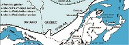
On-screen: geographical map showing Lake Ontario and the Champlain Sea. The areas where Clovis were found are indicated with red dots. Change of map for a map indicating Nova Scotia, New Brunswick, and Maine as well as part of the coast of the United States and a section of Quebec. Early and Late Palaeoindian sites are indicated, along with lithic sources.
[ A.C. ] About 12 500 years ago, descendants of the Clovis had dispersed throughout the United States. They had reached the shores of the Atlantic Ocean, as evidenced by the fluted points found there. Some followed the coast as far as Nova Scotia. New England was an interesting spot given its sources of raw material rich in silica. The few locations where this material is found were often visited by the earliest inhabitants, as indicated by the tools and points of the same material found at a number of archaeological sites.
On-screen: image of arrowheads made from chert and from rhyolite.
[ A.C. ] Thus, nomadic groups shared a lithic network in which the use of rhyolite and chert from New England was predominant, as confirmed by geoarchaeological analyses. One may also believe that the Palaeoindians had a system for trading materials, objects, and ideas.
On screen : landscape of trees in shadows and a cloudy sky with a sunrise shining through.
[ P.A. ] In summer, some went hunting to the north. This is how archaeologists believe the settlement of the Eastern Townships began. The first humans to settle in the region probably arrived from New England.
On-screen: map showing Lake Megantic and New England. Footprints heading north from the south are visible.
[ A.C. ] The Palaeoindians followed the Kennebec River, crossed the border mountains, and settled near Lake Megantic, one of the first locations in Quebec to be freed from the ice. The archaeological items discovered at the Cliche-Rancourt site are very similar to New England assemblages.
On-screen: map showing the various locations inhabited in the region south of the St. Lawrence River and in Nova Scotia during the Palaeoindian era.
[ A.C. ] Other hunters followed the coastline and reached the Maritimes. The Debert site in Nova Scotia also contains indicators of human presence dating from 12 000 years ago.
On-screen, scrolling videos: stretch of water with chunks of ice floating away, mountain covered with trees and snow, close-up of tree needles, grain of pollen enlarged by microscope with the title Spruce pollen.
[ A.C. ] When the climate began to warm up around 11 700 years ago, deglaciation resumed. In the region, climate warming caused a growth in spruce and fir stands, which formed increasingly dense forests, attracting a broader diversity of animals. The analysis of pollen grains taken from core sediment samples from the bottom of lakes and from buried humus confirmed this hypothesis.
On-screen: A photograph of two arrowheads, one long and pointed and the other shorter and a bit oval.
[ A.C. ] Between 11 000 and 10 000 years ago, one or two other nomadic groups, with two new types of points, spent time at these locations. Evidence of their presence has been found at all Eastern Townships Palaeoindian archaeological sites. Evidence from the Late Palaeoindian culture, also known as Eastern Plano, is very prevalent at the Kruger 2 site in Sherbrooke.
On-screen: map to the south of the St. Lawrence River showing the location of the various sites inhabited during the Palaeoindian era.
[ A.C. ] The discovery of similar points in the American West indicates that these hunters were present there. They adapted their points to an increasingly forested setting. It is believed that they followed the shores of the Great Lakes before arriving and settling in the region.
On-screen, scrolling videos: Fish swimming in a lake, beaver swimming and carrying a tree branch, beaver dam, close-up of logs in flames.
[ A.C. ] The numerous bones from food scraps found at the Kruger 2 site indicate that the wildlife was diverse and that the Palaeoindians from this era ate a variety of fish and wildlife. The many flakes found indicate the presence of a stone-chipping work area. The presence of firestone and a heated rhyolith biface at this site enabled dating using optically stimulated luminescence. Therefore, the area was inhabited about 10 000 years ago.
Geographical map of the south of the St. Lawrence River from the Palaeoindian era on which the Gaspésie region is indicated.
[ A.C. ] Some Palaeoindian groups from the Plano culture ventured north, up to the Gaspésie.
On-screen, scrolling videos: mountain covered in trees and snow, deer eating vegetation along a dirt road, hardwood tree branch covered with leaves in autumn colours with a blue sky in the background, brook with water falling from one level to the next, photograph of a fluted arrowhead with text: Middle Archaic period, about 8 800 to 6 800 years ago and a 5-centimetre scale, photograph of an arrowhead with a peduncle with the text: Laurentian Archaic period, roughly 6 800 to 4 500 years ago.
[ A.C. ] For the next 6 000 years, warmer temperatures continued to be conducive to the diversification of fauna and flora. Maple trees were growing freely, as shown by pollen analyses. The use of new resources lead to a transformation of tool-making techniques. The Archaic culture arrived with its polished and bush hammered tools, such as hatchets and gouges, its polished chipped points with a peduncle and lateral notches, its fish hooks, and its bone needles. Traces of this culture were found on the Gaudreau site in Weedon.
On-screen: clock hands moving forward in time. Scrolling photos: Information: Early Woodland period, approximately 3 000 to 2 400 years ago, with a photo of an arrowhead along with rectangular artifact consisting of two holes in its centre, information: Middle Woodland period, approximately from 2 400 to 1 000 years ago, with a photo of an arrowhead accompanied by a square artifact with many small holes, information: Late Woodland period, approximately 1 000 to 400 years ago, with a photo of a triangle-shaped arrowhead accompanied by an artifact that looks like a bottleneck with a five-centimetre scale, rock in the night with a starry sky.
[ A.C. ] 3 000 years ago, the Archaic period ended, to be replaced by the Woodland period, corresponding with the introduction of ceramic work and later agriculture. Ecological conditions were similar to those of today. As Indigenous peoples moved less, the gap between cultural differences widened and different people developed their own identity. Some formed nomad tribes, while others became sedentary and practised farming.
On-screen: close-up of ripe and unripe raspberries. Scrolling images: Painting of Europeans arriving by boat meeting Indigenous peoples on a river, an overview of a library row, black and white photograph of two Indigenous women sitting in front of a wooden house, current picture of an Indigenous ritual where traditional clothing is worn and drums are played, river with calm water and, finally, a dream catcher attached to a tree.
[ A.C. ] Improvements in living conditions led to considerable growth in Indigenous populations. Then, some 400 years ago, the first Europeans arrived in North America, bringing along written documents. This was therefore the end of prehistory for this part of the continent, since later, the main events can be traced back through written documents. The arrival and settlement of Europeans profoundly transformed the way of life of Indigenous peoples. Today, Indigenous peoples represent about 1% of Canada’s population. There are at least 750 generations between them and their ancestors who crossed Beringia.