
The video clip below shows the results from the analysis of the raw material used by prehistoric humans to make their tools. After viewing it, review the other elements from the folder to get an overall picture of the theme. If you would like to learn more, consult the Artifacts content for each archaeological site in the expert section presented by Claude.
Enjoy exploring!
Clip produced by the Sherbrooke Museum of Nature and Science
Date : September 2018
Length: 5:01
An animated character, Éric Graillon, presents the raw materials used by Palaeoindians to make their tools. An analysis of the chemical composition made it possible to track their geological source in New England. This discovery is the basis for the hypothesis that the first Palaeoindians arrived from that region.
On-screen text: Materials
[Animated character] Materials
Images scrolling on a black board: Prehistoric humans working with stone, pyramids, caribou herd on the plains, brook with tree branches and rocks.
[A.C.] What raw materials did prehistoric humans use for making their tools and hunting weapons? Regardless of the period, humans have done what they could with the materials at their disposal. Some 12 000 years ago, the Palaeoindians worked with stone, roots, plants, and various animal parts like bones, skin, antlers, tendons.... Those living in forested areas also used wood from trees. However, because organic materials do not last over time, only stone artifacts bear witness to this distant past.
On-screen: Text and images alternately scrolling on a blackboard: Lithic artifact, with a photo of a chipped stone; Lithic industry, with a photo of an expert observing various stone objects; Lithic assemblage, with a photo of an archaeological site in a forest.
[A.C.] An object made from stone is a lithic object. All of these remains are identified as lithic industry. Lithic industry objects collected at the same site form a lithic assemblage. The study of lithic assemblages and of lithic industry is the basis for all hypotheses on the origins of the settlement of Quebec and of the Eastern Townships.
The text : The qualities of rock from lithic industry is displayed
[A.C.] The qualities of rock from lithic industry
A video of a waterfall with a river and pebbles is displayed.
[A.C.] What makes one rock better than another to make a tool? Not all rocks can be used to make tools. The best rocks are those that break in predictable patterns when hit. Stone is described as being chippable. No surprise there!
On-screen: Images of rocks on a waterfront and a clip of dice rolling a few times.
[A.C.] The rock must also be solid enough to resist the impacts of tool use, but malleable enough to be created. Thus, the rocks used must be relatively homogeneous with no cracks, internal fissures, or fault lines.
A clip of an impact-resistant chipped stone is shown on screen, followed by an illustration of a stone carved in the shape of a projectile point.
[A.C.] Thus, rocks must be relatively homogeneous with no cracks, internal fissures, or fault lines. High quality stones contain a large proportion of silica, a natural form of silicon dioxide (SiO2) with similar grains.
Images of small rocks in a river are displayed, followed by a photo with piles of sand grains.
[A.C.] Films and books on prehistory often mention tools made of flint. No tool made of flint has been found in North America; there is no flint on this continent.
On-screen: Images of a library, followed by the word flint, with a red X on it.
[A.C.] Films and books on prehistory often mention tools made of flint. No tool made of flint has been found in North America; there is no flint on this continent. Lithic tools are primarily made of rhyolite, hornfels, chert, shale, quartzite, massive rocks, most of which are rich in silica.
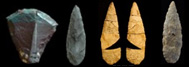
Photographs of various stones are displayed with their identification: Rhyolite, hornfels, chert, shale, and quartzite.
On-screen text: Lithic resources: their location
[A.C.] Lithic resources: Their location
[A.C.] Geoarchaeologists are not only interested in identifying raw materials, they are also interested in their origin.
Two scrolling photos: Expert observing classified chipped stones; expert with two maps, one geographical, the other geological.
[A.C.] This challenge is comparable to a crime scene investigation. Experts are not content with determining the calibre of the projectile, they try to find the crime weapon.
Images of police lights are displayed, followed by a lab illustration.
[A.C.] They must sample its physicochemical signature to determine its original location. Geoarchaeologists therefore conduct physicochemical analyses on lithic artifacts.
On-screen: Three photographs of stones magnified 100 times under the microscope, followed by a lab illustration.
[A.C.] They work on the objects themselves without destroying them, but occasionally damage a tiny part of the object to remove thin slices for further analysis.
An image with microscopes in a lab is displayed, followed by a car driving on a road winding through forests and mountains.
[A.C.] They also analyze rock samples from various rock outcrops with the characteristics sought for making tools.
A car driving on a road winding through forests and mountains is displayed, followed by a close-up on a rock outcrop.
[A.C.] After analysis, all outcrops are documented on files. The Centre de référence lithique du Québec has a collection of more than 500 geological samples that may have been used in the past to make stone tools.
A photograph of filing cabinets containing chipped stones of various shapes, colours, and sizes is displayed.
[A.C.] These samples are primarily from Quebec, but also elsewhere in the country. The United States also has a lithic reference centre. The physicochemical signatures of the artifacts’ materials are also recorded. If they correspond to a documented source, the archaeologist has information about the mobility of the occupants or their trading network. The same is true if the artifacts found are of the same material as those found at other sites.
Scrolling videos: View of a Quebec landscape, view of an American landscape, close-up of a hand using a computer mouse.
On-screen text: Origin of materials found in the Eastern Townships
[ A.C. ] Origin of materials found in the Eastern Townships
A picture of coniferous forest in winter and of pebbles at the edge of a river is displayed.
[A.C.] Palaeoindians in the Eastern Townships likely used locally sourced materials to make their tools. Some of these sources have not yet been located, either because they haven't been found, are no longer accessible, or have been depleted. Materials may also have been sourced from pebbles gathered in a river.
An image of a rock mountain and some conifers is displayed.
[A.C.] Some analyses conducted on lithic tools from the region are consistent with those from Vermont, Maine, and New Hampshire. Sources of excellent quality materials are scarce, so rare in fact that the few spots with such outcrops were frequently visited by the first inhabitants, with the same materials being found at many sites.
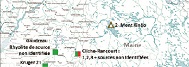
A geographical map indicating the lithic sources is displayed. Location 1 - Munsungun, Location 2 - Mount Kineo, Location 3 - Mount Jasper, Location 4 - Lake Champlain. The Cliche-Rancourt site (Early and Late Palaeoindian site) has sources from locations 1, 2, 3, and unknown places; the Gaudreau site (Late Palaeoindian site) has rhyolite from an undetermined source; the Kruger 2 site (Late Palaeoindian site) has materials from local and undetermined exotic sources as well as from locations 1 and 4.
[A.C.] There is reason to believe that the Palaeoindians who arrived in the region came from New England. Furthermore, the provenance of tools of similar stones, found on sites hundreds of kilometres away, supports the hypothesis that the Palaeoindians moved around a lot and had a vast trading network. New archaeological discoveries and the discovery of new sources could help in drawing a more accurate portrait of the way of life of the earliest inhabitants.
Scrolling videos: Map of Maine in the United States, waterfalls at the edge of a river viewed from rocky banks, winter scene of a sparse forest covered in snow, expert digging a hole at an archaeological site, and other experts cleaning artifacts and categorizing them on planks.